Domestic flights within Chile are very affordable, but crossing the Andes by air can easily double to price of airfare. So although the Argentinian town of Calafate has its own airport, we flew to Puerto Natales in southern Chile and crossed the border by bus. All in all, including the time it took for us all to go through customs, the bus journey took about 6 hours.
 |
| We're looking surprisingly chipper in this photo even though we had to get up early after a night of almost-no sleep in a loud, over-heated hostel :0 |
Dinner
 |
| Maya's favorite meal of the trip! Lamb is a specialty in Patagonia (we saw sheep grazing over hours of long bus rides), and this place's lamb did not disappoint! |
Perito Moreno Glacier
Pretty much everyone goes to Calafate for one reason- the Perito Moreno glacier. Tours leave every day to give you any kind of glacier experience you can imagine: glacier lookouts, glacier views from a boat, walks on a glacier, 6 hour long treks on a glacier, and whiskey cooled with a piece of glacial ice.
We chose to do a tour of the glacier with Hielo y Aventura. We originally planned to go with a different tour company, but they tried to raise the price of the trip when it was time to pay. We told them we were only interested in the original price, and then ghosted them. Over the next 48 hours they sent us a series of messages lowering the price all the way down to the original price- but that seemed sketchy so we went with Hielo y Aventura who had demonstrated the ability to pick a price and stick to it.
They picked us up and brought us to a boat. On the road there, we got intermittent glimpses of the glacier, but we didn't get a great view until the boat pulled out and rounded a small peninsula. Observing glaciers is a strange experience. The first time Matt saw one, he distinctly remembers thinking it was about 10 feet high and maybe 100 feet away. He now realizes it was probably hundreds of feet high and a mile away. Perito Moreno is about 250 feet high, and 3 miles across. Our guide said he had hike to the point where the glacier is growing in the mountain- it was a multi-day backpacking trip! Considering how easily he leaped and bounded around the glacier, we imagine it would take your average person considerably longer.
 |
| Waiting for our boat ride to the Perito Moreno Glacier |
We got off the boat at the foot of the glacier, donned helmets and crampons, and began a tour of a small corner of the glacier that is constantly surveyed and monitored for crevasses and holes. The path changes as the glacier changes to ensure safety.
 |
| Lookout glacier- here we come! |
 |
| Putting on Cramp-Ons before heading onto the ice- note other tour groups in the background. |
 |
| The people showed here are constantly working with ice picks to maintain the trek trail. |
The surface of the glacier has no snow- only ice! It's a solid sheet of ice that honestly looks like chunks of ice from a freezer fused together.
 |
From a distance the glacier looks like it's covered in ridges a few feet high. In reality each ridge is a sizable hill, with deep valleys in between.
|
Water drains through deep holes that appear intensely blue. We were warned to stay away from any holes large enough to fall into.
The water is safe to drink- but due to a lack of minerals it will pass into cells through osmosis and can cause them to lyse. Drinking only pure glacial meltwater can apparently kill you :/
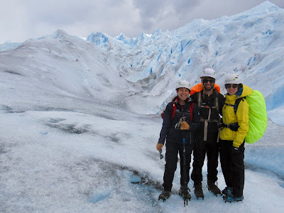
Lots of pictures of us on Perito Moreno- it was hard to resist all the photo opportunities.
 |
| You'll notice the ice looks "bluer" in this photo- Maya edited to "match her memory." |
The glacier naturally advances and recedes with the seasons, and occasionally butts up against a peninsula in front of it. This has two effects. First, the peninsula provides an incredible view out over the glacier. And second, the contact between the glacier and the land cuts the lake in two. On one side there is no drainage and the water level can vary by many meters. Eventually as the glacier recedes, water will burst explosively through and begin a long process of draining from one side to the other until the water levels equalize. Our next stop was a lookout on the point of the peninsula where there are a series of walking paths with different views of the glacier. Every so often, the glacier calved- the sound and the size of the splash helped but into perspective the enormity of the ice.
Walking on the glacier was a neat experience, but I think we all agreed that seeing the glacier from above is more impressive. While walking on the glacier it's hard to truly sense how large and expansive it is since your view is blocked by the closest ice walls.
 |
| Another one of Maya's photos edited to "match her memory" |
 |
| Matt (standing) and Maya (sitting) |
 |
| Karen particularly liked the way this bright blue chunk of ice looked. You can notice how much bluer it was by comparing it to the rest of the glacier in the photo above. |
After our 10-hour tour, we had a couple hours of downtime at our hostel before catching a 3-hour bus ride to our next stop: Chalten. The view from the bus was pretty neat- check out the shadow of the cloud below. It looks like it's zooming by!


No comments:
Post a Comment
Note: Only a member of this blog may post a comment.